|
OrbBuoy
|
|
|
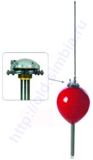
MIP SSB Radio Buoy
The new Marine Instruments’ MIP Radio Buoy is designed specifically for use on longline vessels, allowing fishing
captains to monitor their fishing lines up to 50 miles away. The MIP Radio Buoy allows
captains to view buoy positions, monitor line drift and identify line breaks.
The MIP Radio Buoy transmits buoy position and battery voltage level in encrypted radio messages
to help avoid detection. The buoy has an internal GPS receiver, rechargeable batteries, durable
stainless steel construction, magnetic (On/Off) switch, high intensity recovery light, and a
small whip antenna.
- Heavy-Duty construction for use on commercial longliners
- 50-mile buoy transmission range
- NO communication cost (radio broadcasts)
- Buoy position reports are encrypted for location security
- Rechargeable batteries
- Batteries are charged via buoy antenna (charger sold separately)
- Buoy can be dismantled for storage inside the vessel
|
|
|
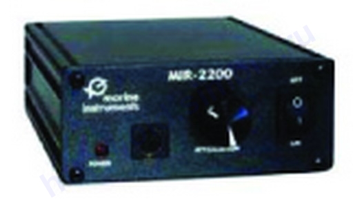
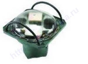
MIR-2200 - Marine Instruments Reception System
Each MIP Radio Buoy transmits encrypted message bursts every 15 minutes containing the
buoy’s GPS position and battery voltage. These secure transmissions are received using
the ship’s SSB radio and the Marine Instruments’ MIR-2200 Reception System. Buoy position
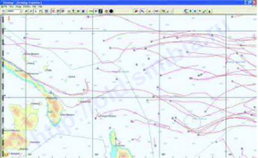
tracks are displayed on C-MAP digital nautical charts with MSB-Longline software. The software
can calculate drift speed and display an alarm in the event of a line break. MIP Radio Buoys
can also be displayed in SeaStar’s OrbMap software.
- Compatible with GeoEye’s OrbMap software
- View track and position of MIP buoy
- Work with more type of MIP buoys
- USB or serial port connection to your onboard PC
|
|
|
|
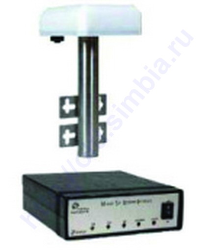
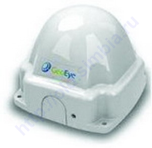
MSR - Marine Satellite Receiver
The Marine Satellite Receiver (MSR) works with GeoEye’s OrbBuoys as an independent
communications system that sends and receives buoy reports and commands.
Whereas normal marine email systems can show delays of varying length, the MSR
utilizes Iridium technology to provide reliable, near-real-time communications.
The system is comprised of an external unit with the Iridium transceiver, GPS receiver and
antenna, along with the required cables for connection to your vessel’s PC via serial
port or USB. Using the MSR with OrbMap software, buoy positions are automatically
plotted on C-Maps charts. The system’s functionality is displayed by LED lights on
the data box, which monitor the status of the transceiver, the GPS signal and the
system’s interface with your PC.
- Compatible with GeoEye’s OrbMap software
- USB or serial port connection to your onboard PC
- Contains an internal GPS receiver
- Compatible buoys: M3I, OBY-200
- Communication type: Iridium
- Internal Iridium terminal
|
|
|
|
GSR - GeoEye Satellite Receiver
GeoEye now offers a GeoEye Satellite Receiver (GSR) built by Skywave that works as an independent
communications system for receiving buoy reports and sending buoy commands.
Whereas normal marine email systems can show delays of varying length, the GSR utilizes
Inmarsat’s latest ISatDataPro technology to provide reliable, near-real-time communications.
The system is comprised of a satellite transceiver along with the required cable for connection
to your vessel’s PC via serial port or USB. When the GSR is combined with OrbMap software, buoy
positions are automatically received and plotted on C-Map charts or on your favorite oceanographic
base maps. No additional hardware is needed, just your PC.
- Compatible with GeoEye’s OrbMap software
- USB or serial port connection to your onboard PC
- Compatible buoys: OBY-200
- Communication type: Inmarsat ISatDataPro
|
|
|
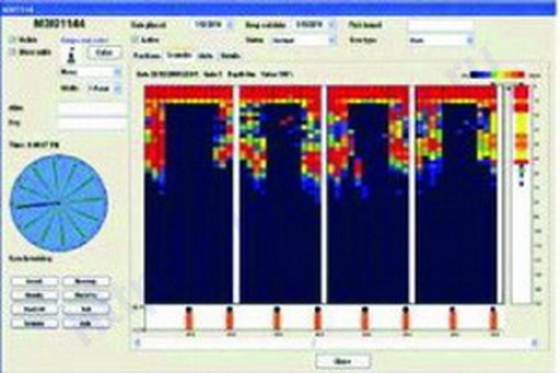
M3I - Sonar Buoy
These buoys are equipped with a 50KHz/500W echosounder, GPS, sea temperature sensor (SST) and
satellite transceiver. They report sonar readings as well as position, SST and battery voltage
back to the vessel at adjustable reporting frequencies. All information is displayed in the MSB
buoy control software.
Position, SST and voltage can also be viewed in OrbMap with the SeaStar Fish Finding Maps.
MSB software allows users to remotely adjust the gain on the echo-sounder for the best possible
results. These features, along with the remotely-activated, high-intensity beacon for nighttime
recovery, are achieved using two-way communication via the Iridium satellite network.
M3I buoys are designed with a double solar panel system as well as an alkaline battery pack,
providing unlimited autonomy.
- Compatible with GeoEye’s OrbMap software
- Compatible with MSR
- Contains an internal Echo-Sounder: 50KHz/500W
- Remout activation
- Software: MSB 2.1 or higher
- Communication type: Iridium
|
|
|
|
OBY-200 - Global Drifting Buoy
This new generation buoy is easily retrieved through the use of high accuracy GPS positioning
and two-way communications via the INMARSAT IsatM2M satellite network that virtually remains
awake and listening for commands. The buoy contains a high-intensity recovery beacon and is
designed with replaceable alkaline batteries that have a two year life expectancy. Location
information and control capability for each buoy is integrated into GeoEye’s OrbMap software,
allowing fishermen to see and track each buoy’s location on top of SeaStar oceanographic maps.
In addition to buoy position, users can interpret real-time currents and obtain sea surface
temperature data transmitted from the OBY-200 buoy. Captains can also use the pre-programmed
reporting frequencies to receive buoy positions or activate the recovery beacon.
- Compatible with GeoEye’s OrbMap software
- Compatible with MSR and GSR
- Contains an internal water temperature sensor
- Contains an internal GPS receiver
- Communication type: Inmarsat ISatM2M
- Remout activation
- Battery Saving Mode
|
|
|
|
M2S - Drifting Buoy
These buoys are designed with solar panel charged gel lead acid batteries for continuous
operation, and are easily retrieved through the use of high-accuracy GPS positioning, two-way
communications (via the INMARSAT IsatM2M satellite network), and a user-activated high-intensity
beacon for nighttime recovery. Location information and control capability for each buoy is
integrated into OrbMap software, allowing fishermen to see and track each buoy’s location on top
of SeaStar oceanographic maps.
In addition to buoy position, users can interpret real-time currents and obtain sea surface
temperature data transmitted from the M2S OrbBuoy. Captains can send commands to change the
pre-programmed reporting modes, or to activate the recovery beacon.
- Fully Compatible with GeoEye’s OrbMap software
- Fully compatible with Marine Satellite Receiver MSR
- Solar panel charged gel lead acid battery with backup alkaline battery
- Contains an internal GPS receiver
- Communication type: Inmarsat ISatM2M
- Remout activation
- Battery Saving Mode
|
|
| |
 |
|
| |
|